Taranaki and Central Plateau, New Zealand
Mountain | reviews | videos | photos
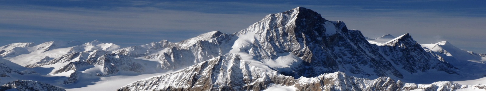
This thermal wonderland of active volcanoes, mighty rivers, alpine tussock and native forests surrounding Lake Taupo, stretches across the regions of Lake Taupo, Ruapehu, Taranaki and into the Whanganui and Rangitikei river valleys. Lake Taupo - the 'beating heart' of the North Island according to Māori legend - was formed thousands of years ago in an apocalyptic volcanic eruption. The lake occupies the ancient crater that's now a playground for water-sports and a world-famous trout fishing spot. Ruapehu, south of Lake Taupo, is a mountainous region that includes Tongariro National Park - a dual World Heritage site recognised for its great natural and cultural value. The park has three volcanoes - Tongariro, Ngauruhoe, and Ruapehu, which boasts the world's only ski field within 500m of an active volcanic crater. Taranaki - on the rugged North Island west coast - is dominated by Mt Taranaki's volcanic cone as it rises majestically above rolling plains and some of the world’s best surfing beaches. The Taranaki region's contrasting landscapes make it suitable for many outdoor activities from surfing to skiing. Tongariro - dual World Heritage area For Māori, the central North Island landscape is of deep cultural and spiritual significance. Legends handed down from generation to generation tell stories of how the landscape came to be. The three active volcanoes - Ruapehu, Tongariro, and Ngauruhoe - are considered such precious treasures that the local Tuwharetoa Māori gifted the vast area to the nation of New Zealand more than a century ago. Tongariro National Park was the first national park in New Zealand, and the first in the world created by gift from an indigenous people. It is recognised as a dual World Heritage Area for its outstanding natural and intangible cultural values. Te Kahui Tupua: the sacred peaks Māori knew the Central Plateau area - south of Lake Taupo - as Te Kahui Tupua / the sacred peaks. Te Kahui Tupua is a spiritual land, encompassing the triumvirate of volcanoes - Ruapehu, Ngauruhoe and Tongariro - and woven together by three rivers: the Whanganui, Whangaehu and Rangitikei. This wilderness landscape ranges from mountains to virgin forest and deep river gorges. Legend of Tongariro According to Māori belief, mountains were once gods and warriors of great strength. Tongariro was one of seven mountains that stood next to each other around Lake Taupo - New Zealand’s largest lake, and source of the Waikato river and spectacular Huka Falls. In the legend, all the mountains were male except for Pihanga. She was a stunning beauty, and the other mountains were deeply in love with her. One night, the mountains decided to fight for the right to win Pihanga. The warrior mountains fought fiercely with violent eruptions, smoke, fire and hot rocks that burned the sky for days. The land trembled and quaked under the force of their anger. When the fighting ceased, mighty Tongariro was the victor. Having won Pihanga’s devotion and the right to stand next to her, Tongariro became supreme leader of the land. The defeated warrior mountains were given the night to move away from the couple. At the dawn of the new day, they would be eternally fixed to the place where they rested. Ngauruhoe and Ruapehu moved off to a respectable distance, just to the south of Tongariro. Putauaki and Tauhara headed to the east. As dawn broke, Putauaki settled at the northern end of the Kaingaroa plain, near Rotorua, and remained there as a mountain sacred to people of the Ngāti Awa tribe. Tauhara, stricken with grief, could not bear to move far from Pihanga. He stayed on the shores of Lake Taupo, perpetually looking back across the lake to Pihanga. Taranaki, consumed by anger, gouged a great trail in the earth as he moved west to a place where he now stands overlooking the ocean below. The trail he left behind was filled with tears cried for Pihanga, and became the great Whanganui River.
11m 26sLenght