Crossing the Swiss Alps: Flight from Locarno (LSZL) to Fricktal (LSZI) in a Piper Super Cub
Mountain | reviews | videos | photos
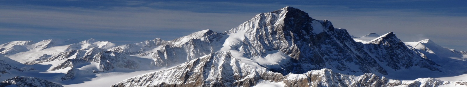
This is a video of my return trip from Locarno (LSZL) back to Fricktal Schupfart (LSZI) after my first flight crossing the Alps. This is my second solo mountain cross country since my mountain familiarisation training this summer. I made the trip in the Motorfluggruppe Fricktal's Piper Super Cub HB-PLQ. The weather was dominated by a high pressure region centred on Finland. As a result the prevailing winds were low. Thus the weather was driven mainly by thermal activity due to solar heating. This resulted in winds flowing up the valleys and up the mountain sides. In the middle of the valley colder dryer air descended to replace the rising air. As a result clouds formed on top of the mountains while the valley centre was clear of cloud. This was more evident in the south east of Switzerland and less so in the west and north possibly due to less humid air there and/or slightly stronger prevailing winds. As there was extensive parachute activity over Ambri I hoped to make the trip back via the San Bernardino pass. However when I got near the pass I could see that it was clouded over. I thought to climb above the clouds, as I heard one other pilot had done later, but as I got to 9500 feet I started to feel woozy from hypoxia so I decided to descend back down to 9000 feet and try the Gotthard pass instead. Zurich Information helped me pass Ambri safely and Gotthard was luckily free of cloud. ATC is included with the video and this is a good example, though my own phraseology is far from perfect, of typical Swiss radio communication.
Comments
-
+Henry F. Thanks. I tried replying directly to your comment but for some weird reason YouTube is preventing me from doing so. So I hope you get this message.
There are a number of opportunities to find out the active runway at an uncontrolled airport in Switzerland similar to most other countries. The first thing I do is to tune into the frequency several minutes before I need to make my first call and listen for other traffic. If there are other planes in the circuit you will quickly hear which runway they are using when they make their traffic calls on the radio. All airports in Switzerland have an office which is marked with a black "C" on a yellow square. Not always is this manned but usually during the day there is someone there. Most such offices have hand held or portable radios and they also monitor the frequency. Therefore if one doesn't already know the active runway it is usual practice when one makes their first call to address specifically the aerodrome and request an aerodrome advisory. If someone on the ground hears this and is able to respond usually they will let you know the current active runway. This does not happen all the time though. It may still occur later if it doesn't happen with the first call, if the person manning the radio missed your first transmission, even without an aerodrome advisory request as you get closer to the airport and make further traffic calls. In the absence of other traffic and a response from the ground then it is necessary to overfly the airport and look for the wind sock to see what direction the wind is coming from. This is done at an altitude above circuit height (typically 500 feet above but each airport in Switzerland has very specific traffic instructions which are published so it is necessary to know ahead of time what altitude you are permitted to overfly and if there are any restrictions such as noise sensitive regions and/or glider, aerobatic and/or parachute boxes which must be avoided). In Switzerland there is also a signal box which shows the active runway with a "T" symbol meant to represent an airplane pointing in the landing direction. This is usually a passive devise which is manipulated by someone at the airfield and less reliable than the wind sock. At a few airports it is an active device linked to a wind gauge and therefore more reliable however unless you know this ahead of time it is not possible to know for certain so it is advisable to check the wind sock for the actual wind direction. I like to check both and make a determination as other aircraft which are not using radios might be adhering to the signal box even though the dominant wind direction as shown by the wind sock has reversed since the signal box was set. In that case it is a matter of common sense judgement and in the case that you feel the wind dictates using the opposite runway to the signal box to be especially vigilant for traffic which may not have a radio using the opposite runway. -
Nice video Geoffrey, really enjoyed it. How long did it take you to get down to Locarno with the Cub? I flew H-LQ to Gruyère yesterday, and it took me almost an hour! Ground speed 78 kts.
-
+Claudio Pedrazzi Thanks. To avoid Ambri I took the Oberlap and Lucomango passes on the way down but I wanted to return by a different route. I knew from the weather reports that there were less clouds in the west so I figured if Gotthard didn't work I had the possibility to go into the Valley of the Rhone and then would have a number of options. I filled up with fuel in Locarno as I knew the weather was not a certainty and in the worst case I could always return to Locarno or even in an absolute emergency Ambri (I still need to do pavement training on the Cub). The GAFOR said it was difficult which is only one level beneath perfect and the instructor I spoke to at Fricktal before setting out was not concerned at all by the weather reports. He felt I would likely need to dodge some clouds, which he said was typical for this time of year, but I should have no problem finding a way through. Having said all that I learnt it might be useful to carry oxygen to give me some options to climb a bit higher if I need to. I didn't like the woozy feeling I had at 9'500 feet and it suggests I might be more sensitive to altitude than the average person, perhaps from too many years living near sea level in the UK and not that much higher in Canada.
-
Very interesting indeed. It was certainly not easy, due to the clouds ceiling. I do not know what I would have done, it could be that I had turned back to Locarno... now I know that it is also possible to "ask" ZH-Info if crossing of a warning area is approved. When I will decide to go, I would also like to use the Gotthard on one leg and the San Bernardino on the other. Or maybe Lukmanier. Anyway, thanks for sharing!
-
Great video, thanks for posting. Very educational with all the ATC in the background. Good call on turning around at San Bernandino!
45m 18sLenght